We are excited to share a new Riverlab article, linked here, published this month in the Journal of Hydrology. This work advances current understanding of the controls on hydrological connectivity of impervious surfaces to downstream channels and storm-sewer networks and presents new methods of their estimation.
Connected impervious areas – those impervious surfaces that contribute directly to runoff in a storm network or stream – are a better indicator of hydrologic response, stream alteration, and water quality than total impervious area. Most methods for quantifying connected impervious areas require major assumptions regarding the definition of ‘connection’, potentially over-simplifying the role of variable climates, slope gradients, soils conditions, and heterogeneous flow paths on impervious surface connectivity.
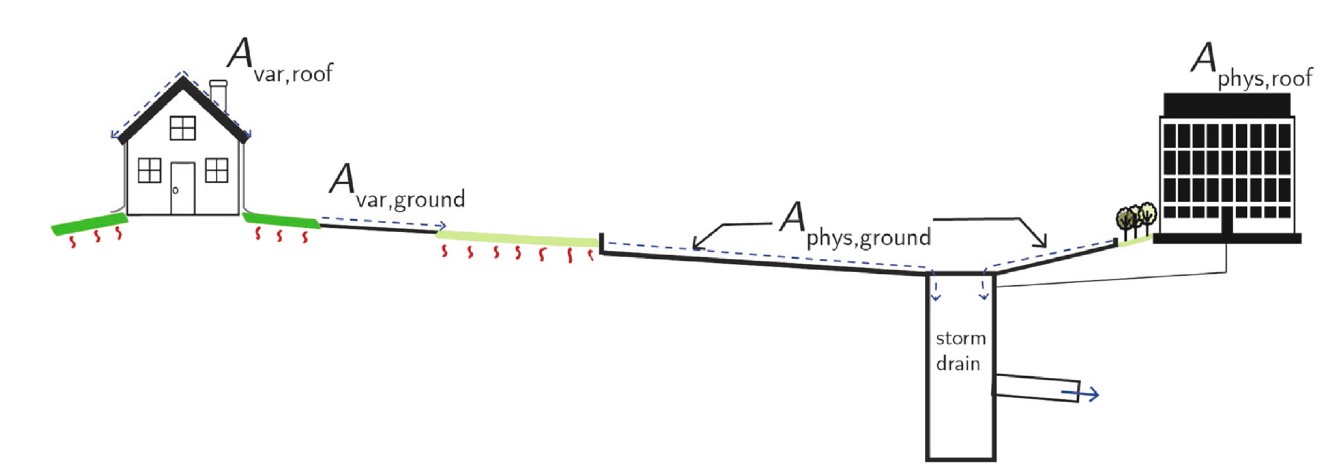
In this study, we present a new metric, hydrologically connected impervious areas (HCIA), to refer to spatially explicit (mapped) estimates of the proportion of impervious surfaces that are hydrologically connected to the storm sewer system or stream network. HCIA is comprised of impervious surfaces that contribute directly to the storm-sewer network and are physically connected, Aphys, or those that contribute indirectly and are therefore variably connected (Avar) (see Figure 1). The degree to which Avar is “hydrologically connected” is represented with a coefficient, ϕvar, that ranges between 0 and 1, with 0 representing full connectivity (i.e. all runoff infiltrates downslope), and 1 representing no connectivity (i.e. no runoff infiltrates downslope).

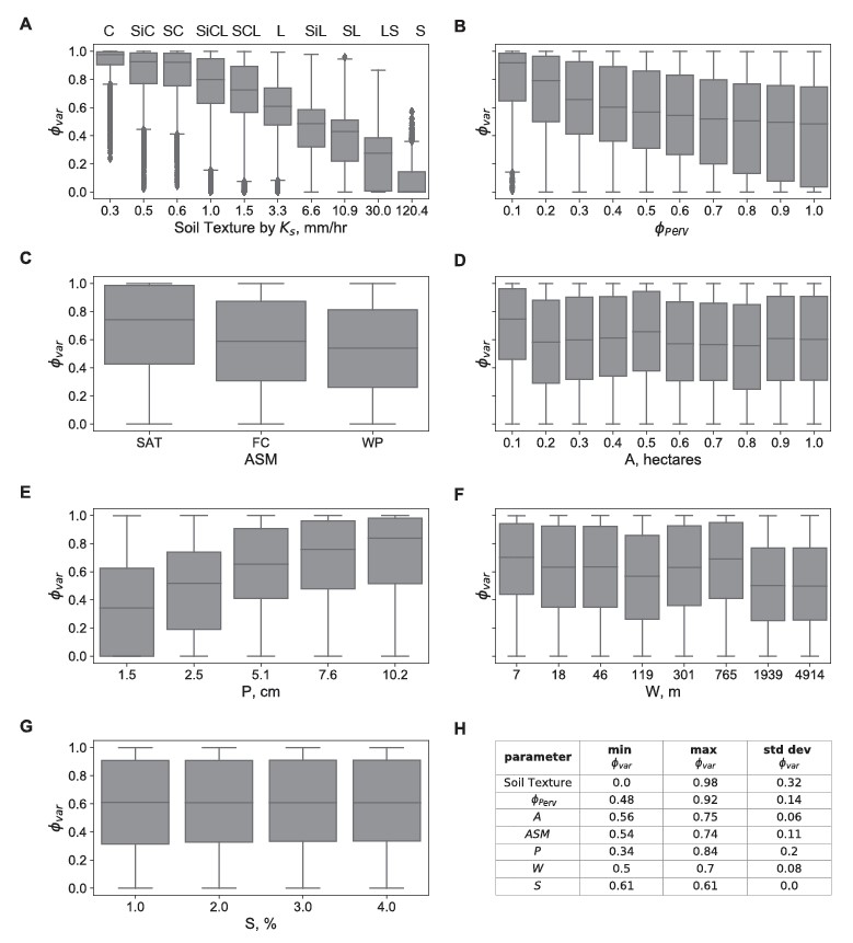
Using a combination of hydrologic modeling in the PySWMM, a python interface for the EPA’s Stormwater Management Model, and machine-learning regression tree analysis, we evaluate the controls on ϕvar across varing soil types, slopes, rainfall scenarios, antecedent soil moisture conditions, as well as amounts of impervious and pervious areas. Figure 6 shows that of the factors tested, soil texture (panel A), fraction of downslope pervious area ϕperv (panel B), soil moisture (panel C), and precipitation (panel D) are sensitive, while total area (panel D), width of impervious area (panel F), and slope (panel G) are insensitive parameters.

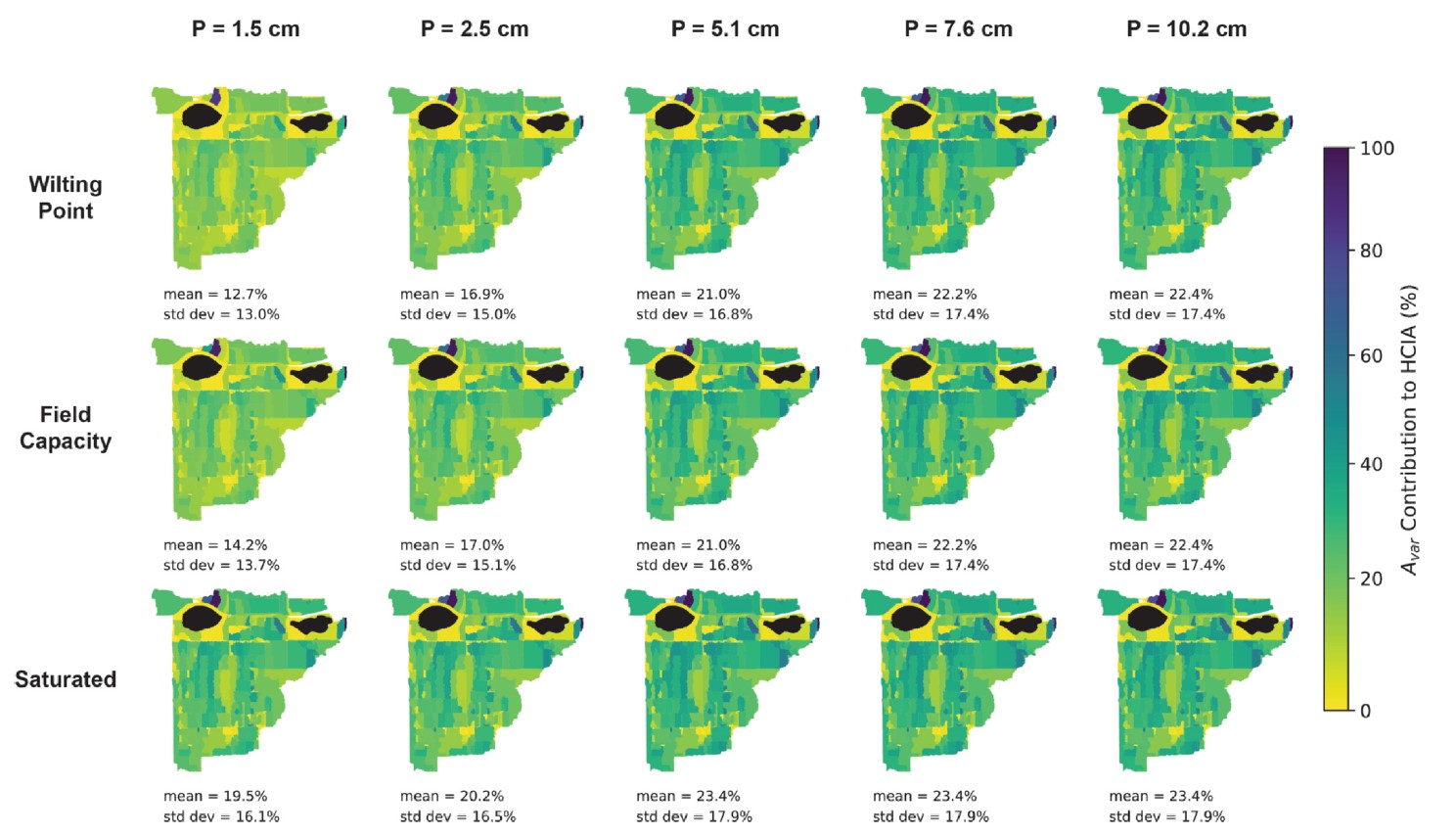
To assist with dissemination of these methods in practice, we apply the regression tree in a geospatial tool for estimation of HCIA in ungauged urban catchments. We test the tool in a case study to an urban sewershed in Colorado, and find that the contribution of Avar to HCIA (compared to the contribution of Aphys) varied across the precipitation and soil moisture conditions. Avar contribution to HCIA was low at low precipitation depths and increased rapidly with increasing precipitation and initial soil moisture conditions (see Figure 9).
Overall, our results suggest that, for catchments consisting of highly impermeable soils, Avar contributes to HCIA such that HCIA approaches the total impervious area, but for catchments with highly permeable soils, Avar does not contribute significantly to HCIA, and thus the physically connected impervious area ( Aphys) could be used as a suitable surrogate for HCIA. In between these two extremes, however, lies a wide range of conditions that call for detailed and spatially explicit estimates of Avar connectivity.
References Cited
Sytsma, A., Bell, C., Eisenstein, W., Hogue, T., & Kondolf, G. M. (2020). A geospatial approach for estimating hydrological connectivity of impervious surfaces. Journal of Hydrology, 591, 125545. https://doi.org/10.1016/j.jhydrol.2020.125545 >>link to paper
