

")
Sediment Management in Regulated Rivers
By trapping sediment in reservoirs, dams interrupt the continuity of sediment transport through rivers, resulting in loss of reservoir storage and reduced usable life, and depriving downstream reaches of sediments essential for channel form and aquatic habitats (Kondolf 1997). With the acceleration of new dam construction globally (global hydropower capacity is expected to double in less than 2 decades), these impacts are increasingly widespread. There are proven techniques to pass sediment through or around reservoirs, to preserve reservoir capacity and to minimize downstream impacts, but they are not applied in many situations where they would be effective. The potential and barriers to implementing sustainable reservoir sedimentation are starkly illustrated by the experience in Taiwan, where globally high erosion rates lead to rapid reservoir sedimentation, which have motivated programs of dredging, sluicing, flushing, and bypass tunnels. The Taiwanese experience demonstrates the challenges that face changing entrenched management approaches to sustainably manage sediment in reservoirs (Wang et al 2018).
Funded by Natural Heritage Institute under a grant from USAID, the UC Berkeley Institute for International Studies, and the Mekong River Commission
Strategies for Sustainable Sediment ManagementThe best way to manage sediments is avoid accumulation in reservoirs in the first place, either by passing sediment around or through dams.

A sediment bypass diverts part of the incoming sediment-laden waters into a tunnel around the reservoir, so they never enter the reservoir at all, but rejoin the river below the dam, while sediment sluicing involves passing high flows through the dam such that the reservoir behaves like a river and transports the sediment through the reservoir. In contrast to sluicing, whose aim is to pass sediment without allowing it to deposit, drawdown flushing scours and re-suspends deposited sediment from the reservoir, and transports it downstream. It involves the complete emptying of the reservoir through low-level gates. Density current venting involves opening dam outlets when turbidity currents pass through the reservoir so that they can remain intact and exit the reservoir via the outlets, carrying most of their sediment with them. Mechanical removal in a drawn-down reservoir can be done with scrapers, dump trucks, and other heavy equipment, or if the reservoir is not drawn down, by dredging using hydraulic pumps on barges with intakes. Sediment augmentation (most commonly, gravel augmentation) involves mechanically adding sediment to the channel downstream to partially mitigate the sediment starvation. See Kondolf et al. (2014) for a summary of these approaches.
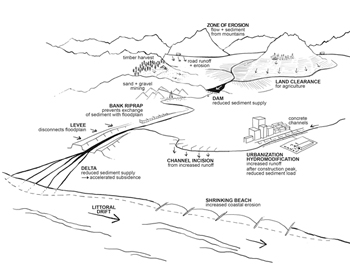
Human alterations increasing sediment yields from the upland landscape, sediment trapping above dams, and consequences of sediment
starvation downstream. (from Kondolf and Podolak 2013)
Check dams have been widely used to reduce upland sediment loads to reservoirs, contributing to substantial reductions in sediment yields in the Loess Plateau of northern China (Zhao et al. 2016). However, the check-dam approach cannot be a sustainable solution of sediment problems in most reservoirs, because once the check dams fill with sediment, they no longer reduce sediment load downstream, and they can become hazardous features in their own right (Wang and Kondolf 2013).

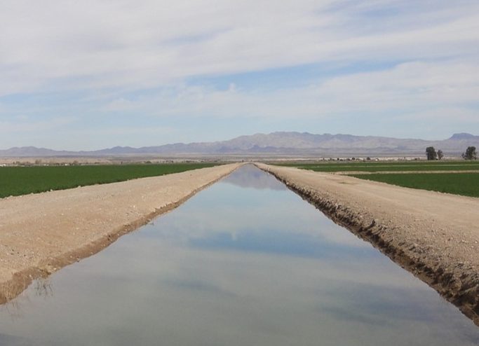
Gravel replenishment to the Sacramento River below Keswick Dam. (Photograph by Matt Kondolf, January 1991, from Kondolf 1997 ‘Hungry Water’)
The small island of Taiwan produces nearly 2 % of all the sediment reaching the oceans from a tiny land area (0.024 % of Earth’s land area). With its highly seasonal precipitation, reservoirs are essential to store water from wet season to dry, but extremely high sediment yields mean these reservoirs are highly vulnerable to filling by sediment. Taiwan’s experience implementing sustainable sediment management approaches shows the effectiveness of strategies such as sediment bypass tunnels, sluicing, and flushing. However, there has been a tendency to avoid the high capital costs of retrofitting for these approaches in favor of annual dredging, which has higher unit costs in the long run (Wang et al. 2018).
References
Kondolf, G.M. 1997. Hungry water: Effects of dams and gravel mining on river channels. Environmental Management 21(4):533-551.
Kondolf, G.M., Y. Gao, G.W. Annandale, G.L. Morris, E. Jiang, R. Hotchkiss, P. Carling, B. Wu, J. Zhang, C. Peteuil, H-W. Wang, C. Yongtao, K. Fu, Q. Guo, T. Sumi, Z. Wang, Z. Wei, C. Wu, C.T. Yang. 2014. Sustainable sediment management in reservoirs and regulated rivers: experiences from five continents. Earth’s Future doi: 10.1002/eft2 2013EF000184
Wang, H-W, and G.M. Kondolf. 2013. Upstream sediment-control dams: five decades of experience in the rapidly-eroding Dahan River Basin, Taiwan. Journal of the American Water Resources Association, DOI: 10.1111/jawr.12141
Wang, H-W, GM Kondolf, D Tullos, and W-C Kuo. Sediment management in Taiwan’s reservoirs and barriers to implementation. Water 10(8), 1034; doi:10.3390/w10081034
Zhao, G., G.M. Kondolf, X. Mu, M. Han, Z. He, Z. Rubin, F. Wang, P. Gao, W. Sun. 2016. Sediment yield reduction associated with land use changes and check dams in a catchment of the Loess Plateau, China. Catena http://dx.doi.org/10.1016/j.catena.2016.05.010

Our lab is working in the Mekong River basin in Southeast Asia, which is undergoing massive dam construction, with 7 mainstem dams completed or under construction in the upper basin (the Lancang River, China) and another 133 dams built, being built, or planned for the tributaries and mainstem of the Lower Mekong River in Laos, Cambodia, and Vietnam. We have analyzed the cumulative impact if all dams are built as originally planned, without any modifications for sustainable sediment management by applying the 3W model (Minear and Kondolf 2009), adapted to the Mekong.

If all dams are built as planned, the sediment supply to the Mekong delta will be reduced by 96%, i.e., the delta will receive only about 4% of its natural sediment load (Kondolf et al 2014, 2015). What would be the downstream effects of this dam-induced sediment starvation? In the bedrock-controlled reaches (which constitute the majority of the Mekong River upstream of Cambodia) surficial sand deposits (typically 1-3m thick over bedrock) will be stripped away, while the alluvial reach near Vientiane will likely incise and experience bank erosion (Rubin et al 2014). The delta is dependent on sediment delivered from upstream to balance losses to subsidence and coastal erosion, and with the reduction in sediment load, the future of the delta is increasingly in doubt. In addition to dam-induced reduction in sediment loads, intensive sand and gravel mining in Vietnam and Cambodia has already reduced sediment delivery to the delta, which contributes to accelerated coastal erosion. Looking ahead to the future of the Mekong Delta, we are analyzing the relative effects of multiple drivers, including accelerated subsidence due to fluid withdrawal, accelerated sea level rise, channelization of distributaries, as well as reduced sediment loads from upstream dams and in-channel mining.
We have analyzed the potential to optimize hydropower production whilst minimizing sediment trapping and other environmental impacts by selecting locations of dams within a river basin. Applying this approach to the Mekong, we analyzed a portfolio of 42 dam sites, all of which have been proposed individually. While the Mekong River Commission has compiled data on dams built, under construction, and proposed, there has been no effort to optimize the distribution of dams within the drainage network to optimize power generation while minimizing environmental impacts. Using the full portfolio, we analyzed a wide range of possible dam configurations using a network sediment connectivity model coupled to a model of reservoir hydraulics, evaluating cumulative sediment trapping for each dam configuration. We identified optimal dam configurations to minimize sediment trapping while maintaining hydropower production. Put another way, different dam configurations can attain similar level of hydropower production at very different levels of sediment trapping. For the Mekong, dam configurations that focus development on dam sites in the upper catchment can exploit up to 80% of the full hydropower potential while trapping only around 20% of pre-dam sediment load. In comparison to added hydro-electric potential, developing large downstream dams invariably results an over-proportional sediment trapping. The current development strategy is based only on the economic interests of individual nations and private developers, resulting in over-proportional impacts on the river network compared to identified optimal configurations. In future phases of our research, we apply this approach elsewhere, including the Irrawaddy and Salween River basins.
The generation of hydroelectric power in rivers is one aspect of the complex web of interactions between water and energy, often referred to as the water-energy nexus. In some cases, the fall of water generates electric power, while in other cases energy is required to move water around the landscape, as widely done in Mediterranean-climate regions (discussed below). We can speak of the water footprint of energy (which would include water requirements and pollution by all types of power plants) and the energy footprint of water (which would include pumping groundwater and pumping water to convey it long distances). As part of a larger research effort under the US-China Clean Energy Research Center, our lab is linking water models with energy models to better understand these interactions in the Southwest US in comparison with two regions in China.

References
Schmitt, R.J.P., Bizzi, S., Castelletti, A., Kondolf, G.M., 2018. Improved trade-offs of hydropower and sand connectivity by strategic dam planning in the Mekong. Nature Sustainability 1, 96–104. https://doi.org/10.1038/s41893-018-0022-3
Kondolf, G.M., Schmitt, R.J.P., Carling, P., Darby, S., Arias, M., Bizzi, S., Castelletti, A., Cochrane, T.A., Gibson, S., Kummu, M., Oeurng, C., Rubin, Z., Wild, T., 2018. Changing sediment budget of the Mekong: Cumulative threats and management strategies for a large river basin. Science of The Total Environment 625, 114–134. https://doi.org/10.1016/j.scitotenv.2017.11.361
Schmitt, R.J.P., Rubin, Z., Kondolf, G.M., 2017. Losing ground - scenarios of land loss as consequence of shifting sediment budgets in the Mekong Delta. Geomorphology. https://doi.org/10.1016/j.geomorph.2017.04.029
Schmitt, R.J.P., Kondolf, G.M., 2017. A global challenge - Riverlab looks at sediment. Water Power and Dam Construction 69, 42.44.
Kondolf, G.M., Z.K. Rubin, J.T. Minear. 2014. Dams on the Mekong: Cumulative sediment starvation. Water Resources Research 50, doi:10.1002/2013WR014651.
Kondolf, GM, G Annandale, and Z Rubin. 2015. Sediment starvation from dams in the lower Mekong River Basin: magnitude of the effect and potential mitigation opportunities. in E-Proceedings of the 36th IAHR World Congress 28 June–3 July 2015, The Hague, the Netherlands.
Minear, T. and G.M. Kondolf. 2009. Estimating reservoir sedimentation rates at large spatial- and temporal-scales: a case study of California. Water Resources Research 45, W12502, doi:10.1029/2007WR006703 online at:
Rubin, Z.K., G.M. Kondolf, and P. Carling. 2014. Anticipated geomorphic impacts from Mekong basin dam construction. International Journal of River Basin Management DOI: 10.1080/15715124.2014.981193

Water Management: Past and Future Adaptation
The interdisciplinary faculty seminar series, Water Management: Past and Future Adaptation, is presented under the auspices of the UC Berkeley Institute of International Studies. As both the developed and developing world confront intensifying demands on rivers and other water resources, impacts are evident from extractions of water for human uses, proliferation of dams, mining sediments from river beds, and intensified land-use impacts, all exacerbated by climate change. Accelerated erosion of coasts and deltas (e.g., from sediment starvation, groundwater pumping, accelerated sea-level rise) are among the manifestations of these impacts. Our seminar takes an interdisciplinary approach these challenges by examining how societies have adapted to variability in the past (uncertainty in water supply, flood risk, etc) and considers the tools we have to manage future variability in river flows and sediment loads, including variability in water supplies, increased flood risk, and the existential threat to many coastal and riverine areas.
To reduce uncertainty in water availability, societies have developed institutional arrangements allocate water supplies and built water supply infrastructure, adaptations that can be traced from ancient times to present. In Mediterranean-climate regions, with their long history of occupation and rich archeological heritage, we can trace such adaptations back millennia. By virtue of their reliably warm, dry summer months, these areas are ideally suited for irrigated agriculture. Through seminars and workshops, our seminar explores social adaptations to variability in water supply and river flow (from droughts to floods), emphasizing the strong parallels among Mediterranean-climate regions and the potential to share design precedents and solutions to these challenges. We have emphasized recent innovations in water management in the European Union implemented in response to the Water Framework Directive (2000) and the Floods Directive (2007), comparing these new management approaches with those prevailing in North America and elsewhere. Products to date from the seminar include a special issue ‘Variability in Mediterranean-Climate Waters: Space, Time, and Intensity’ the open-access journal Water, and the book Flood Risk Management (Palgrave-MacMillan) summarizing trends in the US and Europe.
Funded by the UC Berkeley Institute for International Studies, 2011-2019. The initial focus of the program was Adaptation to Variability: Water Management in Mediterranean Climates, which expanded as the program evolved.
Variability in Mediterranean-Climate Waters: Space, Time, and Intensity
Mediterranean-climate regions face distinct challenges to natural resource management, land-use planning, and design of the built environment: summer drought; highly seasonal precipitation and river flow, and the consequent adaptations to these conditions needed by biota; high inter-annual variability in precipitation; episodic floods and sediment transport. Nonetheless, civilizations have flourished in water-limited Mediterranean environments for millennia. An understanding of how ancient societies adapted to these environmental stressors can inform our current challenges, as both the developed and developing world confront growing water shortages driven by population increases, expansion of irrigated agriculture, and climate change. To reduce uncertainty of water availability in Mediterranean-climate regions, modern societies have developed legal and institutional arrangements allocate water supplies and built water supply and control infrastructure at a scale far exceeding the degree of control seen in more humid climates, altering the seasonality of flow of streams and rivers in these regions.

A special issue in the online journal Water (editors Matt Kondolf and Ben Porter) examines variability in water in Mediterranean-climate regions from physical, biological, social, and institutional perspectives, drawing lessons from the range of adaptations employed by diverse cultures, many of which may be applicable elsewhere, especially as climate change is expected to increase the variability of precipitation worldwide.

By virtue of the potential for irrigated agriculture in Mediterranean-climate regions, water diversions now alter the seasonality of flow and the perennial/intermittent patterns of streams and rivers in these regions to a far greater degree than comparable infrastructure in humid climates (Batalla et al. 2004, Kondolf and Batalla 2005). With their highly seasonal flows, streams in Mediterranean-climate rivers and streams are highly sensitive to water diversions, such as those in the Russian River basin (Deitch et al. 2009, 2009; Deitch and Kondolf 2012). California is like other Mediterranean-climate regions in having strong impacts on river hydrology from water storage and diversions, but it is unique among Mediterranean regions in having native anadromous salmon, including species listed under the federal Endangered Species Act, which consequently create severe constraints on river management (Deitch and Kondolf 2015). Given the highly variable flow regimes and sediment loads, river restoration in Mediterranean climates has constraints not encountered in humid-climate regions (Kondolf et al. 2013).
Many of these water-related conflicts are illustrated in the Russian River basin, for which an an Independent Science Review Panel was formed. Professor Kondolf chaired the panel, which released its report in September 2016 (Kondolf et al. 2016). The panel reviewed existing information to characterize the Russian River drainage, and its hydrologic and ecological processes, and identify important data gaps. The panel developed conceptual scientific models of hydrologic and geomorphic processes in the included regions of the watershed. The report is available at www.russianriverisrp.org
References
Batalla, R.J., C.M. Gomez, and G.M. Kondolf. 2004. Reservoir-induced hydrologic changes in the Ebro River basin (NE Spain). Journal of Hydrology 290, 117-136.
Kondolf, G.M., and R.J. Batalla. 2005. Hydrological effects of dams and water diversions on rivers of Mediterranean-climate regions: Examples from California. In C. Garcia and R.J. Batalla (eds.) Catchment dynamics and river processes: Mediterranean and other climate regions. Elsevier, London. pp.197-211.
Deitch, MJ, and GM Kondolf. 2015. The incendiary mix of salmon and water in Mediterranean-climate California, Chapter 12 in Sustainable Water: Challenges and Solutions from California, pp.269-291, A Lassiter, ed, University of California Press, Berkeley.
Deitch, M.J., and G. M. Kondolf. 2012. Consequences of variations in magnitude and duration of an instream environmental flow threshold across a longitudinal gradient. Journal of Hydrology 420–421: 17–24. DOI:10.1016/j.jhydrol.2011.11.003
Deitch, M.,J., G.M. Kondolf, and A.M. Merenlender. 2009. Hydrologic impacts of small-scale instream diversions for frost and heat protection in the California wine country. River Research and Applications 25: 118-134.
Deitch, M.J., G.M. Kondolf, and A.M. Merenlender. 2009. Surface water balance to evaluate the hydrological impacts of small instream diversions and application to the Russian River basin, California, USA. Aquatic Sciences: Marine and Freshwater Ecosystems 19: 274-284.
Kondolf, G.M., K. Podolak, and T.E. Grantham. 2013. Restoring Mediterranean-climate rivers. Hydrobiologia 719:527-545. DOI 10.1007/s10750-012-1363-y
Kondolf, GM, L Marcus, R Adams, J Bredehoeft, J Constantz, M Cover, C Farrar, M Marchetti, V Resh, and FD Shields. 2016. Report of the Russian River Independent Science Review Panel.
As part of the interdisciplinary faculty seminar, Water Management: Past and Future Adaptation, we have hosted several workshops dealing with flood risk management in the US and overseas, including workshops on the ‘wise use’ of floodplains, non-structural approaches to flood risk management, and flood bypasses, all involving experts from the US Army Corps, state and local agencies, the EU Commission and EU member states, NGOs, consultants, and academics. These workshops have informed recent and pending publications, including Ludy and Kondolf (2012), Lopez and Kondolf (2015), and Serra-Llobet et al. (forthcoming 2017).
References
Lopez-Llompart, P, and GM Kondolf. 2015. Encroachments in floodways of the Mississippi River and Tributaries Project. Natural Hazards DOI: 10.1007/s11069-015-2094-y
Ludy, J. and G.M. Kondolf. 2012. Flood risk perception in lands ‘protected’ by 100-year levees. Natural Hazards 61(2):829-842. DOI: 10.1007/s11069-011-0072-6
Serra-Llobet A, Kondolf GM, Schaefer K, Nicholson S. (eds) 2017. Managing flood risk: perspectives from big floodplain rivers and urban streams (Palgrave Macmillan, due early 2017)

River Restoration
River restoration has enjoyed enormous popularity in recent decades, with tremendous investments but relatively modest efforts to objectively gauge success. We have continued to work in the areas of post-project appraisal of river restoration, hydrologic, ecological and social connectivity of rivers, and aesthetic preferences underlying river restoration designs and perceptions.
Funded by the Walton Family Fund, the Beatrix Farrand Endowment of the University of California, the Landscape Architecture Foundation, and the Contra Costa County Flood Control and Water Conservation District.
The Espace de Liberté and Restoring ProcessEssential to successful restoration is an orientation to process, connectivity, and understanding the larger catchment context of a given site (Kondolf et al. 2006, Wohl et al. 2005). Given the ecological benefits of dynamic channel migration, and the potential for rivers to self-heal if allowed sufficient room to flood, erode and deposit sediment, and migrate, arguably the best strategy for river restoration is to provide the river with a wide corridor, known variously as an espace de liberté, erodible corridor, territorio fluvial, or channel migration zone (Kondolf 2011, 2012). Where upstream dams have irrevocably altered fluvial processes, it can still be possible to restore some processes and habitats through release of more dynamic flow regimes and augmentation of sediment supply downstream of dams (Yin et al. 2014), with measurable ecological benefits from such ‘dynamic construction’ of gravel bars (Ock et al., 2015). Research on the bar morphology and surface-groundwater exchange through gravel bars has continued with Erin Bray’s studies in the San Joaquin River. On rivers with cohesive banks and localized bank erosion, reaches where bank erosion is most likely can be identified for setbacks, in lieu of uniform setbacks along the entire stream channel (Beagle et al 2015).
Large wood provides essential channel complexity and aquatic habitat, but is commonly removed from river channels to avoid it being caught on bridge piers and small culverts. To compensate for loss of habitat from wood removal, habitat enhancement structures (including logs cabled to banks) are commonly installed. In this approach, wood is seen as the ‘problem’, whereas the problem is really bridge openings that are too small to pass the wood load. Over about 50 years, the cost of enlarging culverts and building clear-span bridges (to pass the wood load) is less than the combined costs of removing wood, building habitat structures, and trying to keep debris from jamming on bridges during floods (Lassettre and Kondolf 2011).
References
Beagle, J.R., G.M. Kondolf, L. Marcus, and R.M. Adams. 2015. Anticipatory management for instream habitat: application to Carneros Creek, California. River Research and Applications. DOI: 10.1002/rra.2863
Kondolf, G.M. 2011. Setting goals in river restoration: when and where can the river ‘heal itself’? in Simon, A. et al (eds) Stream Restoration in Dynamic Fluvial Systems: Scientific Approaches, Analyses, and Tools. Geophysical Monograph Series Vol.194 pp.29-43. American Geophysical Union, Washington DC. DOI: 10.1029/2010GM001020.
Kondolf, G.M. 2012. The espace de liberté and restoration of fluvial process: When can the river restore itself and when must we intervene? River Conservation and Management, P. Boon & P. Raven, editors. John Wiley & Sons, Chichester. pp.225-242.
Kondolf, G.M., A. Boulton, S. O'Daniel, G. Poole, F. Rahel, E. Stanley, E. Wohl, A. Bang, J. Carlstrom, C. Cristoni, H. Huber, S. Koljonen, P. Louhi, and K. Nakamura. 2006. Process-based ecological river restoration: Visualising three-dimensional connectivity and dynamic vectors to recover lost linkages. Ecology and Society 11 (2): 5. [online] URL:
Lassettre, N.S. and G.M. Kondolf. 2011. Large wood in urban stream channels: re-defining the problem. River Research and Applications. DOI: 10.1002/rra.1538
Ock, G., D. Gaeuman, J. McSloy, and G.M. Kondolf. 2015. Ecological functions of restored gravel bars, the Trinity River, California. Ecological Engineering 83:49-60. http://dx.doi.org/10.1016/j.ecoleng.2015.06.005
Wohl, E., P.L. Angermeier, B. Bledsoe, G.M. Kondolf, L. MacDonnell, D.M. Merritt, M.A. Palmer, N.L. Poff, and D. Tarboton. 2005. River restoration. Water Resources Research 41, W10301, doi:10.1029/2005WR003985.
Objectively evaluating river restoration projects is essential for the field to advance, but is rarely conducted (Downs and Kondolf 2002). Graduate student research projects can provide independent post-project appraisals that follow up on initial baseline, as-built, and immediate post-project surveys (Kondolf et al. 2011), and class studio projects can provide fresh ideas for local creek groups and agencies (Kondolf et al 2013). Projects to increase habitat heterogeneity have been implemented in a variety of environments. Measures of aquatic macro-invertebrate populations can be used to assess restoration project performance (e.g. Rios-Touma et al., 2014), but widely-employed diversity indices are not necessarily the most appropriate measures in all circumstances. In Mediterranean-climate regions, river restoration can be especially challenging, in light of the highly variable hydrology and sediment loads that naturally occur, and the degree of change induced by dams and diversions (Kondolf et al. 2013, Kondolf et al. 2007). Restoration opportunities are often presented as part of infrastructure or other development projects (e.g., MacWilliams et al. 2010, Chin et al. 2009, Tompkins and Kondolf 2007).

Among our recent studies, we assessed the large-scale riparian restoration efforts along the lower Colorado River under the ‘Multi-Species Conservation Plan’ (a restoration program exceeding $600M investment), reviewing restoration plans, monitoring data, and collecting field data to assess success of restoration projects. Our results suggest that the approach taken of large-scale irrigated plantations of cottonwoods distant from the river has not produced viable habitat for some target bird species, in part because the sites away from the river lack insects required by the birds for food. A paper summarizing this research is in review after revision. Jen Natali’s ongoing research assesses the geomorphic evolution of restoration projects in meadows of the Sierra Nevada range, such as the widely implemented ‘pond and plug’ approach.

We evaluated project performance of three river restoration projects: Tassajara Creek, Napa River, and Yuma East Wetlands, reflecting a wide range of environmental conditions and project objectives, within the Landscape Performance Series of the Landscape Architecture Foundation, available on-line at:
References
Chin, A., S. Anderson, A. Collison, B. Ellis-Sugai, J.P. Haltiner, J. Hogervorst, G.M. Kondolf, L.S. O’Hirok, A.H. Purcell, and E. Wohl. 2009. Linking theory and practice for restoration of step-pool streams. Environmental Management 43:645-661.
Downs, P.W., and G.M. Kondolf. 2002. Post-project appraisal in adaptive management of river channel restoration. Environmental Management 29:477-496.
Kondolf, G.M., S. Anderson, R. Lave, L. Pagano, A. Merenlender, and E. Bernhardt. 2007. Two decades of river restoration in California: What can we learn? Restoration Ecology 15(3):516-523.
Kondolf, G.M., S. Anderson,, R. Storesund, M. Tompkins, and P. Atwood. 2011. Post-project appraisals of river restoration in advanced university instruction. Restoration Ecology 19(6):696-700. doi: 10.1111/j.1526-100X.2011.00803.x
Kondolf, G.M., K. Podolak, and T.E. Grantham. 2013. Restoring Mediterranean-climate rivers. Hydrobiologia 719:527-545. DOI 10.1007/s10750-012-1363-y
Kondolf, G.M., L.A. Mozingo, J.R. McBride, K. Kullman, and S. Anderson. 2013. Teaching river restoration: experiences from interdisciplinary studio instruction. Landscape Journal 32:95-112.
MacWilliams, M.L., M.R. Tompkins, R.L. Street, G.M. Kondolf, and P.K. Kitanidis. 2010. An assessment of the effectiveness of a constructed compound channel river restoration project on an incised stream. Journal of Hydraulic Engineering 136(12): 1042-1052. DOI: 10.1061/(ASCE)HY.1943-7900.0000196
Rios-Touma, B., C. Prescott, S. Axtell, and G.M. Kondolf. 2014. Habitat restoration in the context of watershed prioritization: the ecological performance of urban streams restoration projects in Portland, OR. River Research and Applications DOI: 10.1002/rra.2769
Tompkins, M.R., and G.M. Kondolf. 2007. Systematic post-project appraisals to maximize lessons learned from river restoration projects: Case study of compound channel construction projects in Northern California. Restoration Ecology 15(3):524-537.

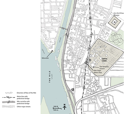
The social dimensions of river management and restoration in urban areas represents an increasingly important area of study (Kondolf and Yang 2008). We have developed a framework for assessing the social connectivity of urban rivers (Kondolf and Pinto 2016), and analyzed use of stream channels by homeless encampments. With colleagues at Berkeley and abroad, we have studied (and continue to analyze) human-river interactions in a range of environments, including the Yellow River floodplain and Pearl River Delta (e.g., Bosselmann et al. 2009) and the Nile in Cairo (Kondolf et al. 2011).

We have also explored the unacknowledged aesthetic preferences that have strongly influenced river restoration project designs. In particular, the preference for single-thread meandering channels is typically accepted without question in North America, despite the fact that such channels are only one of many possible channel patterns that exist in nature (Kondolf 2006, Podolak and Kondolf 2015). These aesthetic preferences may have their roots in notions of beauty that were explored by 18th century philosophers and reflected in landscape designs of that era (Podolak et al. 2013) Moreover, despite the well-established benefits of dynamic channel migration, these channels are designed to be stable, even where channel migration would not threaten infrastructure (Kondolf 2006).
References
Bosselmann, P.C., G.M. Kondolf, J. Feng, G. Bao, Z. Zhang, and M. Liu. 2009. The future of a Chinese water village: alternative design practices aimed to provide new life for traditional water villages in the Pearl River Delta. Journal of Urban Design 15(2):243-267.
Kondolf, G.M. River restoration and meanders. 2006. Ecology and Society. [online] URL:
Kondolf, G.M., P. Pinto. 2016. The social connectivity of urban rivers. Geomorphology
Kondolf, G.M., and C-N. Yang. 2008. Planning river restoration projects: Social and cultural dimensions. pp.43-60 in D. Sear and S. Darby (eds.) River Restoration: Managing the Uncertainty in Restoring Physical Habitat. Wiley, Chichester.
Kondolf GM, et al. 2011. Connecting Cairo to the Nile: Renewing life and heritage on the river. Institute of Urban and Regional Development Working Paper No. 2011-007. University of California, Berkeley.
Podolak, K., and G.M. Kondolf. 2016. The line of beauty in river designs: Hogarth’s aesthetic theory on Capability Brown’s eighteenth-century river design and twentieth-century river restoration design. Landscape Research 41:149-167. DOI:10.1080/01426397.2015.1073705
Podolak, K., G.M. Kondolf, L. Mozingo, K. Bowhill, and M. Lovell. 2013. Designing with nature? The persistence of Capability Brown’s 18th century water features. Landscape Journal 32:51-64. doi:10.3368/lj.32.1.95
Each December, we present the Berkeley River Restoration Symposium (now in its 12th year), with a keynote talk followed by presentation of graduate student research and an expert panel commenting on themes raised by the research projects. The symposium typically draws about 80 attendees from community creek groups, agencies, consultancies, NGOs, and academia.


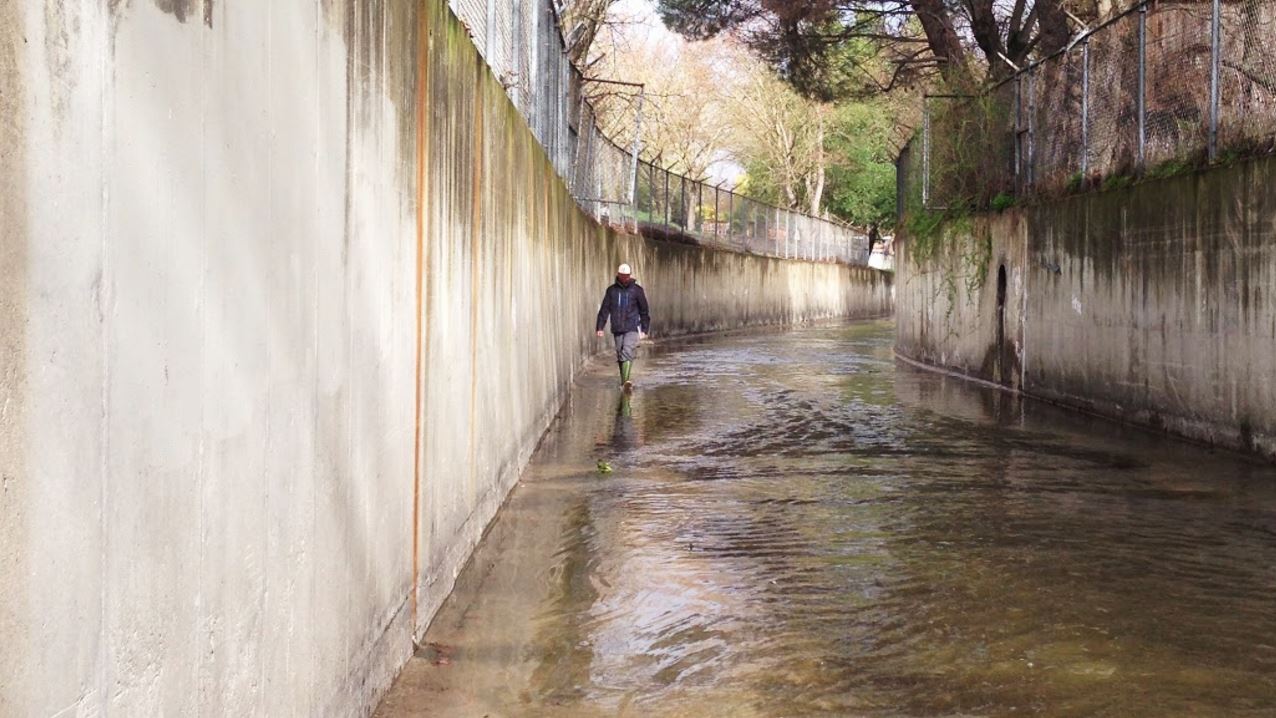
Aging Flood Control Infrastructure and Concrete Channels
Concrete channels represent a widespread flood control technology in urban areas where minimizing the footprint of the stream channel allowed for maximized developable lands. While these channels are efficient at conveying flood water quickly downstream, they have significant ecological and social impacts.
Raymond Wong’s dissertation research documented the design problems that have plagued many concrete channels built in the San Francisco Bay region through the 1950s-1970s, and the maintenance challenges they pose to flood control agencies who have inherited the responsibility for their operation and management.
Like any infrastructure, concrete channels have a finite life, typically about 75 years. The lifecycle of these channels was not addressed when the channels were initially designed and constructed. Decommissioning looms large as a future infrastructure challenge.
Contra Costa County's Fifty-Year Plan
In 2009, Contra Costa County adopted the “50-Year Plan” to address the future of its 79 miles of engineered flood control channels (concrete as well as earthen trapezoidal channels). To support planning efforts by the County, Riverlab researchers are working to publish Walnut Creek Watershed Restoration Opportunities: Realizing the Social and Ecological Potential of Creeks and Riparian Corridors and Walnut Creek Watershed Opportunity Atlas.
Our graduate environmental planning studios have worked with Contra Costa County to assess potential strategies to replace engineered channels of the Walnut Creek system with natural channels (generally preferred by the public), to explore specific actions that could be taken near-term, as well as reaches that pose long-term challenges due to lack of space and access, and where encroached buildings and infrastructure limit alternatives.
Our 2013 conference, The Future of the Concrete Channel, drew an audience of nearly 200 people and provided a forum in which to explore the issues arising from these channels and options for future management, from the small urban channels scaling up the Los Angeles River.

")