A collaboration between Jackson State University and the University of California Berkeley
Green Heart of the Pearl River plan recommends public access for all and prioritizing solutions for tributary flooding of low-income neighborhoods
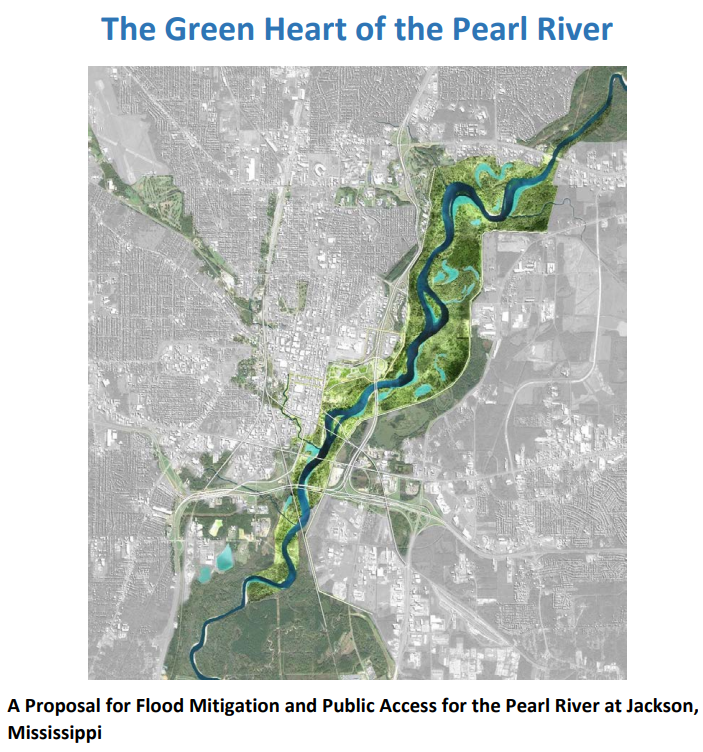
UC Berkeley and Jackson State University students and faculty collaborated to address the chronic flooding occurring along the Pearl River and its tributaries in Jackson, MS, as well as lack of public access to green open space. The students’ ‘Green Heart’ plan proposes to preserve the bottomland floodplain of the Pearl River to accommodate floodwaters and serve as open space accessible to all, structural interventions to relieve flows constrictions in the river and tributaries so urban areas can better drain, and restore the tributaries that flow through Jackson to create green public spaces that also provide effective flood mitigation for all residents. To be effective, this planning process must meaningfully engage residents.
Read the full report here: The Green Heart of the Pearl River.

Issue: Public Riverfront Access & Flood Mitigation
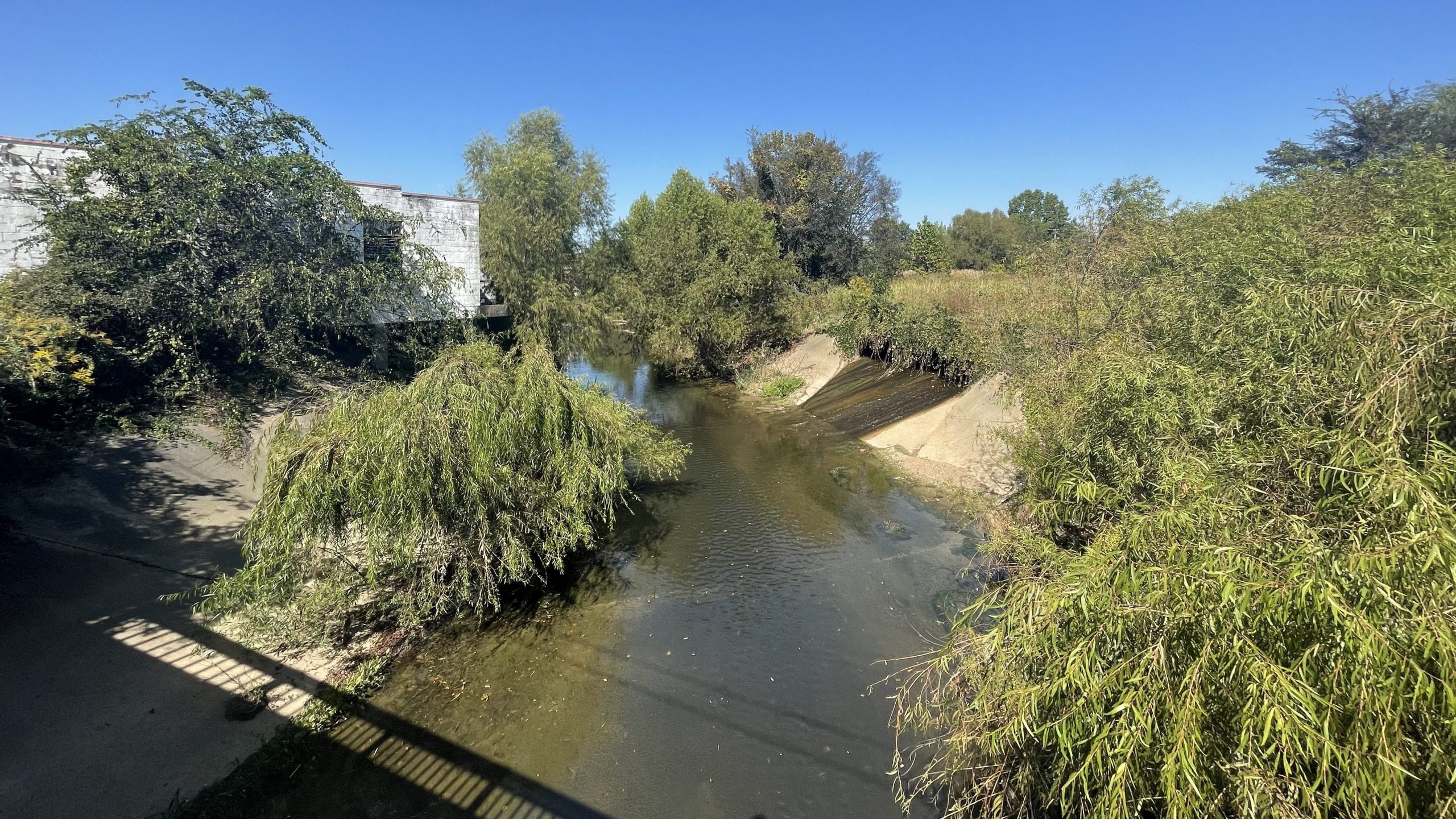
Riverfronts are increasingly valued as public space, but along some large rivers, cities and towns are cut off from their rivers by levees and other flood control infrastructure. For example, until the 1990s, one could visit New Orleans and never see the river because visual access was cut off by artificial levees built on top of the natural levees. While New Orleans has since improved this situation in the touristic downtown area, the problem persists in most parts of the city, and it has long been the case upstream along the Mississippi River in the state of Mississippi. With the exception of some recently developed access points in Vicksburg, Greenville, and Tunica, most of the Mississippi riverfront in Mississippi is without public access. As river banks historically provided important open space and leisure opportunities for people of all walks of life, cutting them off represents a significant impact on recreational opportunities for many in society, notably disadvantaged residents. Flood control structures have cut people off from what is arguably the most important landscape feature in their region.

The Collaboration
In this project, two faculty and five students each from Jackson State University (JSU) and UC Berkeley (UCB) collaboratively assessed sites along the Sacramento River in California in May, and along the Mississippi at Vicksburg in October, making recommendations to improve public access in light of current land use, flood control constraints, and evolving opportunities. The team also drew lessons from the August 2022 Pearl River flooding in Jackson, which disproportionately affected historically marginalized communities in underserved neighborhoods. The collaboration is led by Professor Berneece Herbert, Chair of the Dept of Urban & Regional Planning, and Professor Talya Thomas, Jackson State University, and Professors Matt Kondolf, Danielle Rivera, and Anna Brand of the Dept of Landscape Architecture and Environmental Planning at UC Berkeley.

Sacramento Workshop
The Sacramento Workshop spanned two days. The first day, Friday May 20th, the students and faculty visited six sites along the Sacramento River and Delta, including Vic Fasio Yolo Bypass Wildlife area, riverfront parks in West Sacramento, and the Sacramento Weir where they were accompanied by Mike Mierzwa of the California Department of Water Resources, as well as Garcia Bend Park in the “Pocket”, the town of Locke, and Sherman Island where they were accompanied by Bryan Brock of the California Department of Water Resources. The second day, May 21st, the students participated in an all-day workshop on UC Berkeley campus, where they heard talks from local stakeholders, and then split into groups to discuss and propose options for improving river access. The groups each focused on a different type of connectivity: Longitudinal Connectivity, Lateral Connectivity, and Vertical Connectivity. You can see their final presentations below.
Longitudinal Connectivity PDF Lateral Connectivity PDF Vertical Connectivity PDF

Mississippi Workshop
The Mississippi Workshop spanned three days, from Friday October 14th through Sunday October 16th. The students and faculty met with stakeholders and conducted field visits in both Vicksburg, Mississippi and Jackson, Mississippi to explore river access and safety along the Mississippi River and the Pearl River. In Vicksburg, students met with the Director of Parks and Recreation and the Director of the Office of Community Development who gave our group a tour of Vicksburg’s waterfront, including Fort Hill, Riverfront Park, and the Old Mississippi Bridge. In Jackson, students met with engineers with the Pearl River Valley Water Supply District who provided a tour of Ross R. Barnett dam and reservoir. In addition, students toured the city of Jackson, talking to local stakeholders and conducting field visits to better understand river front access, and the impacts of recent and historic flooding on communities. After field visits, students split into three groups to conduct further research. The groups each focused on a different topic: River Access in Vicksburg, River Access in Jackson, and Flooding in Jackson. You can view their final presentations below.
River Access in Vicksburg PDF River Access in Jackson PDF Flooding in Jackson PDF
Community Workshops in Jackson
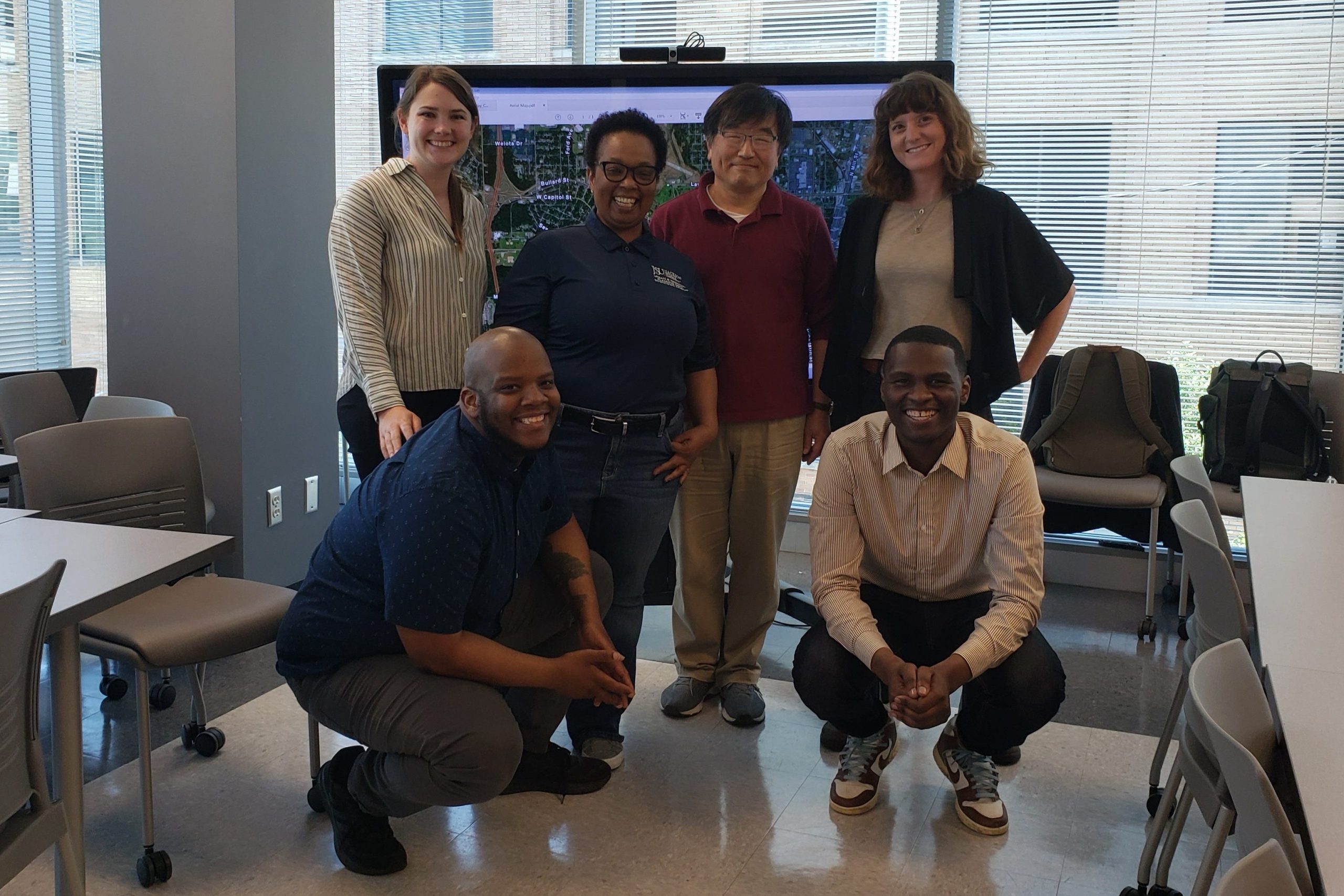
Students in the Environmental Planning Studio at UC Berkeley continued working on the issue of flooding and river access along the Pearl River in and around Jackson, MS during the Spring 2023 semester. Students engaged with stakeholders from Jackson, MS, and collected data around hydrology, social vulnerability, flooding, and urban design, to inform the creation of a preliminary management plan. In May 2023 two UC Berkeley graduate students and two Jackson State University graduate students, working under the leadership of Professors Berneece Herbert, Jae-Young Ko, and Matt Kondolf, brought these ideas to the community to begin a necessary process of community engagement. To facilitate community feedback and participation, the research team hosted two stakeholder meetings at JSU, the first to bring together members of community organizations and government agencies, and the second to bring together and lift the voices of residents. A final proposal for flood mitigation and public access along the Pearl River was completed in July 2023, and can be found here: The Green Heart of the Pearl River. The plan outlines the history of flooding, the need to make room for flood waters, and recommends that detailed tributary management planning be done with communities as partners in the planning process. This process is far from over, but this report and these community meetings are a good first step to an effective, community-based management plan.

Links to Relevant Documents
USACE (US Army Corps of Engineers). 2024a. Pearl River Basin, Mississippi Flood Risk Management Project, Draft Environmental Impact Statement. (most easily accessed on the website of the Pearl Riverkeeper: https://www.pearlriverkeeper.com/2024-deis.html)
USACE (US Army Corps of Engineers). 2024b. US Army Corps of Engineers Strategic Plan to Advance Environmental Justice: A civil works program for all. 27 November 2024. Online at https://usace.contentdm.oclc.org/utils/getfile/collection/p16021coll6/id/2533. Also available on River Lab website: https://berkeleyriverlab.org/2025/01/u-s-army-corps-of-engineers-strategic-plan-to-advance-environmental-justice/.
Kondolf, GM, A Serra-Llobet, M Smeltzer, A Dodd, H Hansen, A Arrington, C Jones, K Deniz, L Liu, B Pundamiera, E Glinskis, H Haidery, B Herbert, T Thomas, J-Y Ko, R Cannady, B Baber, T Hinton, L Stewart, J-V Holden, M Gonzalez, W Millan, X Yao. (2023). The Green Heart of the Pearl River Plan: A Flood Mitigation Proposal for the Pearl River at Jackson, Mississippi. Report from the Spring 2023 LA205 Environmental Planning Studio and the Reconnecting with Big Rivers initiative, University of California Berkeley and Jackson State University. http://berkeleyriverlab.org/wpcontent/uploads/Green_Heart_of_the_Pearl_River-July2023.pdf.
Comments on DEIS from agencies and NGOs. Available at website of Pearl Riverkeeper: https://www.pearlriverkeeper.com/2024-deis-comments.html
The project is coordinated by Prof Berneece Herbert (JSU) and Prof Matt Kondolf (UCB).
Funded by the Beatrix Farrand Endowment, Riverlab, and Global Metropolitan Studies (UCB), and AAG Bridging the Digital Divide and MARTrec grants (JSU).
Co-sponsored by US Army Corps of Engineers San Francisco District Flood Risk Management Program, and the California Department of Water Resources Floodplain Management Office