Many cities worldwide now have available waterfront land, often in the city center, thanks to de-industrialization and concentration of navigation elsewhere. As cities seek to take advantage of this remarkable real estate, they may be prone to some classic ‘traps’ such as copying projects successful in another city but which fail in the new location due to differences in scale, topography, urban form, etc. In this recent publication, Pedro Pinto and Matt Kondolf present an idiosyncratic list of ‘wrongs’ that are evident in many such projects. The paper is freely available, via open access here.
Pinto, JP, and GM Kondolf. 2020. The fit of urban waterfront interventions: matters of size, money and function. Sustainability 12: 4079; doi:10.3390/su12104079
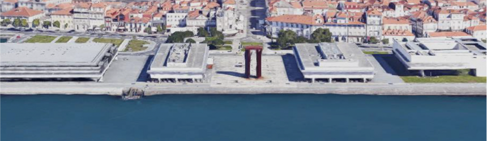
Figure 1. Viana do Castelo, Portugal: three recently built, out-of-scale public buildings cut off the old town from the Lima riverbanks. (source Google)
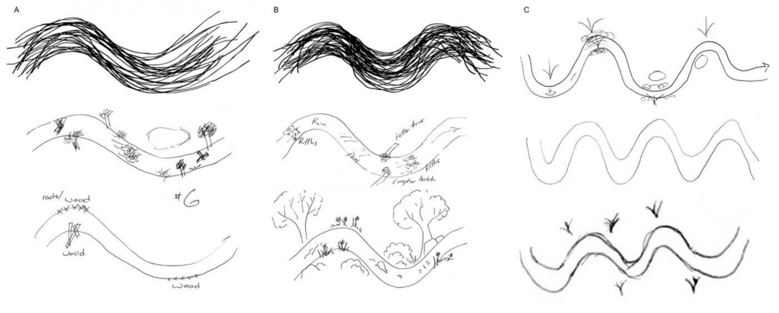
River restoration projects in North America that involve reconfiguration of stream channels are dominated by symmetrical, single-thread meandering channels. Although the meander dimensions are commonly justified by relations between channel width and meander wavelength, the universal preference for single-thread meandering channels in restoration projects is rarely questioned. The aesthetic appeal of s-shaped curves in art and landscape design may help explain the prevalence of this form in river restoration projects. Riverlab alumna Kristen Wilson (Nature Conservancy) gave 300 freshwater scientists attending her keynote talk 5 minutes to draw a restored stream. She compiled the results to see what mental images these scientists had for restored channels. Most depicted single-thread meanders for their restored channel, although there were interesting variants. See Kristen’s just-published paper here.
Figure 1. The ideal meander with its repeating, regular, and symmetrical bends as drawn by select respondents, isolated to the channel pattern, and overlaid to emphasize the similarity in the form. A.—One wavelength. B.—1.5 wavelength. C.—Two or more wavelengths drawings.
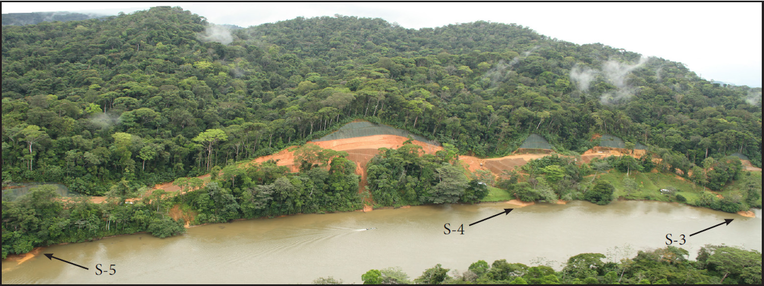
Throughout the humid tropics, increased land disturbance and concomitant road construction increases erosion and sediment delivery to rivers. Building road networks in developing countries is commonly a priority for international development funding based on anticipated socio-economic benefits. Yet the resulting erosion from roads, which recent studies have shown result in at least ten-fold increases in erosion rates, is not fully accounted for. While effects of road-derived sediment on aquatic ecosystems have been documented in temperate climates, little has been published on the effects of road-induced sediment on aquatic ecosystems in developing countries of the tropics. Along the south bank of the Rio San Juan (Nicaragua and Costa Rica), attempts to build a road without engineering or plans resulted in massive failures and erosion in areas where steep slopes impinge upon the river bank. Pre-existing tributary streams received elevated sediment loads, creating new deposits on pre-existing tributary deltas. In some reaches with rapidly eroding sites, completely new deltas of freshly deposited sediment were formed, prograding into the river channel.
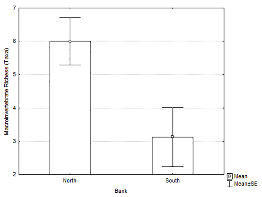
Riverlab alumni Blanca Rios and Scott Walls joined with Matt Kondolf to study periphyton biomass and macroinvertebrate communities on the deltas of Río San Juan tributaries, comparing north-bank tributaries draining undisturbed rain forest with south-bank tributaries receiving runoff from the partially-built road experiencing rapid erosion. Periphyton biomass, richness and abundance of macroinvertebrates overall, and richness and abundance of Ephemeroptera, Plecoptera and Trichoptera were higher on the north-bank tributary deltas than the south-bank tributary deltas. These findings were consistent with prior studies in temperate climates showing detrimental effects of road-derived fine sediment on aquatic organisms. A Non-Metric Multidimensional Scaling (NMDS) analysis showed the impacted community on the south-bank deltas was influenced by poorly-sorted substrate with greater proportions of fine sediment and higher water temperatures. The paper is freely available (open-access) here.
Rios-Touma, B, GM Kondolf, and SP Walls. 2020. Impacts of sediment derived from erosion of partially-constructed road on aquatic organisms in a tropical river: the Río San Juan, Nicaragua and Costa Rica. PLoSONE 15(11):e0242356. https://doi.org/10.1371/journal.pone.0242356
Figure 1. Reach of Rio San Juan from approximately River Km 83.3 to 84.3 (downstream of the outlet of Lake Nicaragua) Figure 2. Macroinvertebrate richness of south-bank versus north-bank tributary deltas of the Rio San Juan, MarchMay 2014.