Category: News

Mapping Connected Impervious Areas in Urban Watersheds

Quantity of impervious surfaces such as buildings, roads, and parking lots, are often used as an indicator of the degree of urbanization and environmental quality in urban areas. Watersheds with high impervious surface coverage experience higher peak flows, decreased infiltration and recharge, and reduced baseflows in streams (Leopold, 1968). This causes streambeds to scour, resulting in loss and degradation of important ecological habitat in-stream and in riparian zones (Gillies, Brim Box, Symanzik, & Rodemaker, 2003).

However, the spatial distribution and connectivity of impervious surfaces as well as the characteristics of the area (e.g., soil conditions, slopes, precipitation patterns) also effect the quantity and quality of stormwater runoff (Jacobson, 2011). In effect, a landscape’s impervious area may be divided into two categories: those that drain to a pervious surface, and those that drain directly to the stormwater or stream network. Because of their direct contribution to storm flows, these directly connected impervious areas are reported to be a better indicator of hydrologic response, biologic integrity, stream alteration, and water quality than total impervious area. Despite this fact, few studies have developed simple and transferable methods for identifying these connected impervious areas. Better identification of impervious surfaces that contribute to stream degradation and alteration can then be directly linked to management actions, such as stormwater fees, tradable stormwater credits, or strategic stormwater management (Roy & Shuster, 2009).

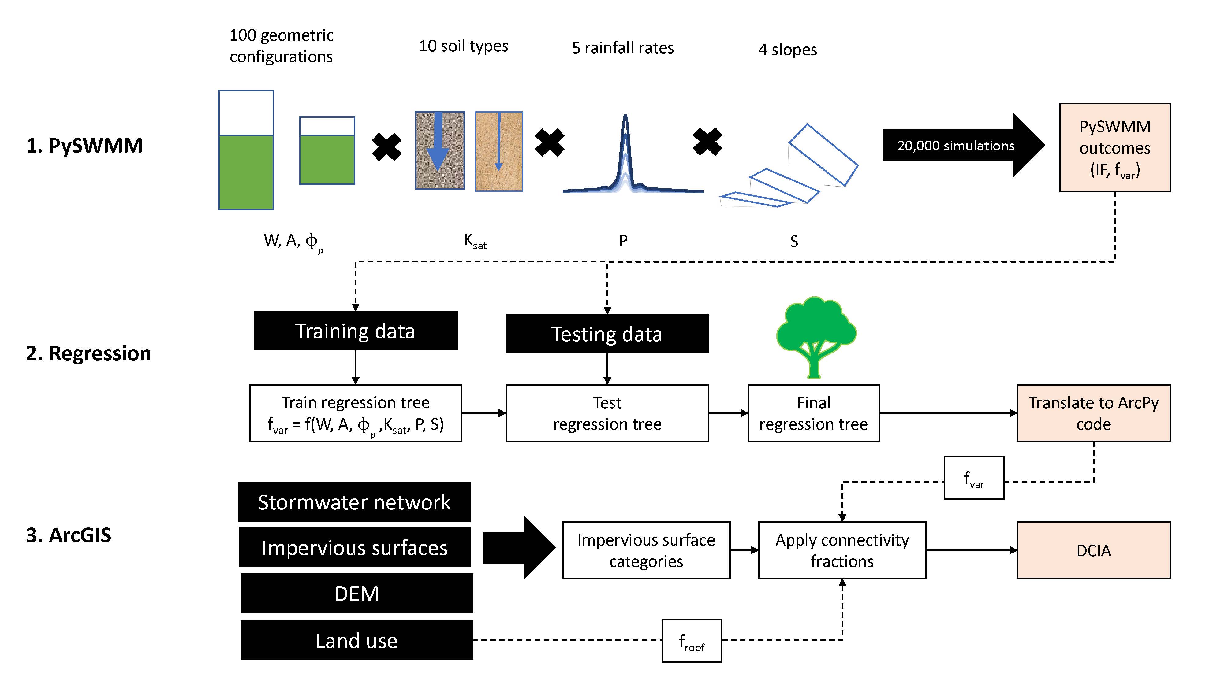
This year, River Lab’s Anneliese  Sytsma is working with ‘Reinventing The Nations Urban Water Infrastructure‘  (ReNUWIt) – an interdisciplinary, multi-institution engineering research center funded by NSF  – to develop a simple and transferable methods of identifying these directly connected impervious areas and evaluate their role in reducing peak flows in urban areas. To do this, she is using combination of remote sensing, geospatial analysis in GIS, hydrologic analysis in ArcHydro, field survey, and stormwater modeling. She is testing her model in the Petaluma River Watershed, in Sonoma County, California.


Sources:

Gillies, R. R., Brim Box, J., Symanzik, J., & Rodemaker, E. J. (2003). Effects of urbanization on the aquatic fauna of the Line Creek watershed, Atlanta—a satellite perspective. Remote Sensing of Environment, 86(3), 411–422. https://doi.org/10.1016/S0034-4257(03)00082-8

Jacobson, C. R. (2011). Identification and quantification of the hydrological impacts of imperviousness in urban catchments: A review. Journal of Environmental Management, 92(6), 1438–1448. https://doi.org/10.1016/j.jenvman.2011.01.018

Leopold, L. B. (1968). Hydrology for urban land planning: A guidebook on the hydrologic effects of urban land use.

Roy, A. H., & Shuster, W. D. (2009). Assessing impervious surface connectivity and applications for watershed management. JAWRA Journal of the American Water Resources Association, 45(1), 198–209.

Dams, Sediment Discontinuity, and Management Responses in Mediterranean River Basins

Friday 05 October 2018, ENS Lyon

By: Gabrielle Bouleau, Carole BarthélémyEmeline Comby, Joanna Guerrin

River basin management has mostly concerned management of water resources, with relatively little attention paid to the sediment continuity essential to maintain downstream channel functions and coastal features.  The sediment loads of most major rivers have decreased in recent decades as a result of extensive trapping of sediment by dams, increasingly manifest in accelerated coastal erosion and loss of delta lands. 

This conference examined three large rivers in southern Europe: the Rhône, Ebro, and Po.  All have headwaters in high mountain ranges and traverse Mediterranean-climate dominated basins.  All three have experienced afforestation of their mountainous headwaters since the 19th century, which has reduced erosion rates and sediment supply to the river system.  All three have been extensively modified and impounded for irrigation water supply, hydroelectric production, flood control, and navigation, mined for production of construction aggregate, and otherwise altered for human uses, and all three evince erosion and subsidence of sediment-deprived deltas. 

For each river, speakers reported on sediment discontinuity and sediment management from both geomorphic and environmental history perspectives (see programme below). One intervention, a social science perspective on sediment in the Rhône, was in the form of a half-hour video, which is available at the link above.  In discussion, speakers and participants from the audience drew comparisons among the three river basins, noting similarities and differences.  There was broad agreement among participants that the topic as framed by the conference merits further exploration. 

The conference was hosted by the Collegium – Lyon Institute of Advanced Studies and the CNRS Laboratory UMR 5600 Environnement Ville Société, and co-sponsored by the Agence Francaise de la Biodiversité, Eléctricité de France, and Companie Nationale du Rhône, in collaboration GRAIE and the Agence de l’Eau Rhône-Méditerranée-Corse.  The conference was coordinated with a broader research effort initiated by Professor G Mathias Kondolf (UC Berkeley) and Asst Professor Giacomo Parrinello (Sciences Po), The Social Life of the Sediment Balance: A Social and Geomorphic Approach to the Transformation of River Systems and Deltas, supported by the France-Berkeley Fund and a UC Berkeley Social Science Matrix-Sciences Po collaboration grant.

>>Conference programme

Adapting to sea level rise: Emerging governance issues in the San Francisco Bay Region

This recently published study by Pedro J. Pinto, Matt Kondolf, and Raymond Wong  (Environmental Science and Policy 90: 28-37) explores examples where actual implementation of SLR adaptation has led, or may lead to, the need to revise standards and practices or require uneasy choices between conflicting public interests.  While there is broad agreement in principle in the San Francisco Bay region on the need to adapt to sea-level rise through innovative approaches, actual implementation has proven difficult because of institutional complexity and communication challenges among stakeholders, including conflicting agency mandates and priorities.  Removing institutional barriers to adaptation will almost certainly require some agencies to adapt their policies, but path dependence is an obstacle.  The article is available for free download until 18 November here

A related paper explores why the SF Bay is so highly vulnerable to sea-level rise by comparison to the Tagus Estuary, Lisbon, Portugal, which is physiographically similar but was subject to a very different development history. A key difference was the role of the US Swamp Act of 1850, which turned tidal lands over from the federal government to states so the latter could encourage drainage and development, leading ultimately to a vast area of urban settlement subject to inundation in coming decades.  By contrast, in Portugal such tidal lands remained in the control of the crown, and were managed mostly for low-intensity agriculture, so today these lands are available to accommodate the landward migration of tidal wetlands with sea level rise, without conflicting with most urban land uses.  The paper,

“Evolution of two urbanized estuaries: environmental change, legal framework, and implications for sea-level rise vulnerability” (Water 8:535) is available online (open access) at http://www.mdpi.com/2073-4441/8/11/535/pdf


‘Horizontal levee’ with migrating ecotone. (adapted from HDR 2015)

Local interests may undermine functioning of Mississippi River flood bypasses

The operation of major federal flood control facilities in the Mississippi River system is compromised by local land-use decisions, which have allowed extensive development within designated flood bypasses, and by local interests who oppose inundation of their lands within these bypasses when needed to manage floods.

See our paper: ‘National-local land-use conflicts in floodways of the Mississippi River system’ by GM Kondolf and P Lopez-Llompart

The Social Life of the Sediment Balance: A social and geomorphic approach to the transformation of river systems and deltas

A new collaborative project will explore the social and natural processes that lead to the modification of sediment balance in rivers. Interdisciplinary scholarship on river systems and society is usually concerned with water flows, but rarely with sediment balance. Sediments, however, are essential components of river systems. Hydroelectric dams, canals, navigation, sand and gravel mining, and other human uses alter sediment fluxes, often with detrimental consequences on the river morphology and ecology as well as on coastal land.

The project will bring together two scholars with different perspectives on this topic: Giacomo Parrinello, Assistant Professor of Environmental History at the Centre for History at Sciences Po (CHSP), brings a social science and history background, while G. Mathias Kondolf, Professor of Environmental Planning and Geography in UC Berkeley’s Department of Landscape Architecture and Environmental Planning, is an expert in the geomorphology of river systems. Parrinello and Kondolf received one of four inaugural grants from the UC Berkeley Social Science Matrix and Sciences Po to develop their project. See Matrix webpage for more details.

Nature Sustainability: Better trade-offs between hydropower production and dam sediment trapping – can this work and how?

2

Paradigms like “the right-project in the right place” have been proposed to make hydropower more sustainable by selecting low-impact / high-benefit dam sites. But what is a good strategy for selecting the right projects and places, and can such strategic hydropower planning really contribute to develop more sustainable hydropower? The February issue of Nature Sustainability “Strategic Planning for Dams” features the research of Rafael Schmitt and Matt Kondolf from UC Berkeley, together with Simone Bizzi and Andrea Castelletti from Politecnicno di Milano (“Improved trade-offs of hydropower and sand connectivity by strategic dam planning in the Mekong” DOI: 10.1038/s41893-018-0022-3). In that paper, we demonstrate that strategic selection of dam sites can greatly improve the trade-offs between hydropower production and dam sediment trapping, one of the key environmental impacts of dams.

The Se Kong, Se San, and Sre Pok form a major tributary basin of the lower Mekong and are a crucial source of sand for the lower Mekong and the Mekong Delta. This sand is of critical importance to build the floodplains of the lower Mekong and the coastline of the Mekong Delta. This sand supply would have been of even greater importance in the future, given that the Mekong Delta, which supports nearly 20 million people, is under substantial danger from rising sea levels and land subsidence (see, for example Schmitt et al. (2017) Losing ground – scenarios of land loss as consequence of shifting sediment budgets in the Mekong Delta
). However, there is also a great need for energy in the basin’s abuting countries. In the 3S basin, countries raced to develop hydropower dams without considering dam cumulative impacts and benefits, or a strategic analysis of which dam portfolios could achieve a given level of hydropower generation with minimal impact on the basin’s sand budget.

In our research, we found that the currently built dam portfolio will trap 90 % of the basin’s sediment load, while exploiting 50 % of the basin’s generation potential. By analysing nearly 17,000 alternative dam portfolios, we found that it would have been possible to generate the same amount of hydropower while trapping less than 20 % of the basin’s sand load. The current dam portfolio includes major dams on the river that carry most sand load. Our alternative portfolio consists of smaller dams in the upper parts of the basin and in rivers that carry naturally less sand.

We hope that our results will motivate additional efforts for building institutional frameworks to streamline strategic system-scale planning into the ongoing hydropower expansion world-wide and hence to find better trade-offs between energy needs and the delivery of fluvial ecosystem services. .