A Social Analysis of the San Marcos River
Lilly Byrd
Carbon sequestration potential on a reconnected floodplain: insights from the Cosumnes River, California
Britne Clifton
Fire and Water: Establishing a Geomorphic Baseline for a Perennial Stream in the Walbridge Fire Footprint
Morgan Cooney, Adrienne Dodd, and Molly Oshun
A Restoration on Yongding River, Beijing
Yifan Feng
Salinas River: Historical context, maintenance, and biodiversity
MaFe Gonzalez
The impact of water level fluctuation on vegetation: An assessment of Zhenjiang Section of Yangtze River
Trista Hu
Riparian vegetated buffer in Chinese urban wetlands: a case study of Xixi wetland, Hangzhou
Karen Jin and Jingyi Chen
Restoring San Leandro/Lisjan Creek: Re-establishing Sacred Relationships as Pathways toward Decolonization
Janet Le
The Urban Gauntlet for Steelhead Trout: A Reconnaissance Study of Habitat in Upper Bollinger and Little Pine Creeks, Contra Costa County
Ali Parmer, Derek Morimoto, and Rebecca Kaliff
Understanding the water, understanding the canyon: establishing a baseline study of the Redwood Canyon reach of Cerrito Creek in Blake Garden
Camille Thoma and Dulce Rivas
The Social Evaluation of the Interval River of Shanghai Houtan Wetland Park
Peixuan Wu, Yuetian Wang, and Zhehang Li
Author: riverlab
Tonle Sap Lake is unique in its ecological and cultural importance. In the rainy season, water flows upstream from the Mekong River to swell the lake to 4 times its dry-season extent, creating extensive shallow water habitat for fish. When the lake drains back to the Mekong through the Tonle Sap River, it creates one of the greatest fishing grounds of the world, providing protein to millions of people. Research by former Riverlab/Fulbright visiting scholar Chantha Oeurng and his student Ty Sok demonstrates evolving flow and sediment relations between the lake and the Mekong River. The just-published paper, Assessment of Suspended Sediment Load Variability in the Tonle Sap and Lower Mekong Rivers, Cambodia, is available for free download until late May from Catena here.
Two Riverlab researchers (Rafael Schmitt and Matt Kondolf) and two Italian colleagues (Simone Bizzi and Andrea Castelletti) have been awarded the 2021 Aspen Institute Italia Award for their joint research on “Improved trade-offs of hydropower and sand connectivity by strategic dam planning in the Mekong” [1]. The scientists are working on this ongoing effort to reduce impacts of the global clean energy transition on rivers and livelihoods.
Building future green economy poses great economic and technical challenge for societies, in part because of the often-overlooked externalities of technology and infrastructure on people and the environment. In their research, the scientists used the example of hydropower development to demonstrate need and opportunity to resolve such conflicts through strategic spatial planning. Hydropower is a well-proven and cost-effective way to generate renewable energy. At the same time, dams can have catastrophic impacts on people’s livelihoods and the fundamental processes that underpin healthy rivers. Thus, there is great concern about the environmental impacts of future dams, mostly planned to energize socio-economic development in the global south.
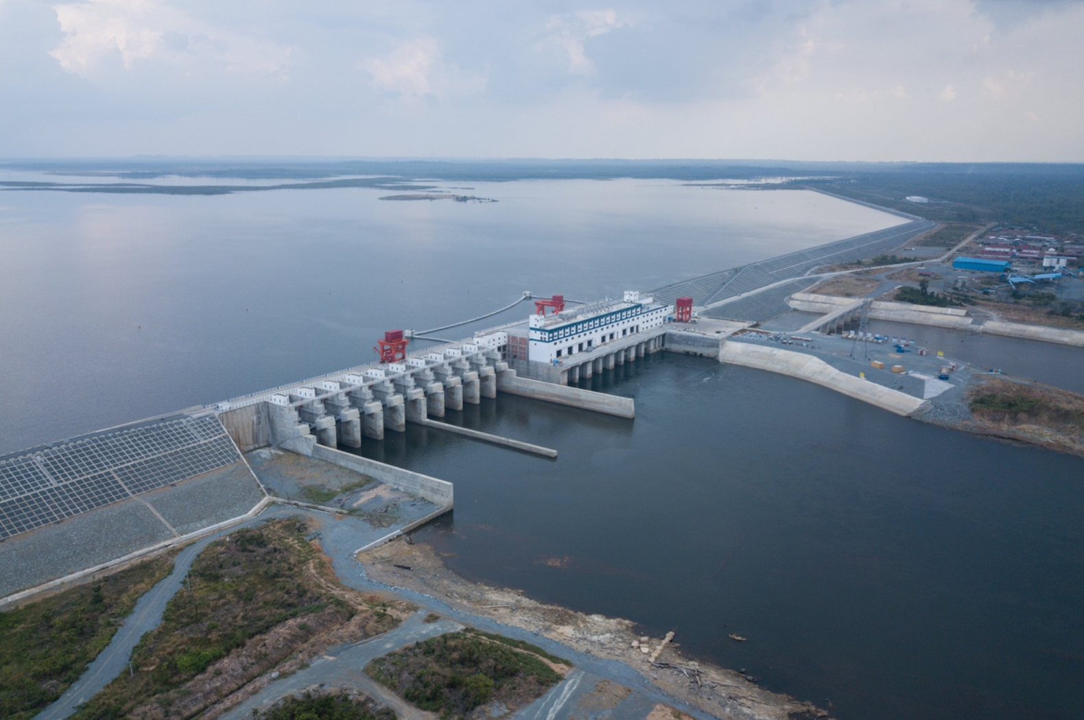
The winning research demonstrated that strategic placement of dams, considering for the spatial heterogeneity of natural processes in rivers and the cumulative impacts of multiple dams, can greatly reduce dam impacts without compromising on energy generation and energy costs. That finding was derived by combining a novel computer model for evaluating large scale impacts of dams on rivers with state-of-the art tools for decision analysis. The study was based on the example of the Mekong River in South East Asia, where a massive hydropower development occurred in the recent past, and more development is foreseen in the near future. Results show that existing dams, exploiting around 50 % of the basin’s hydropower potential, have major impacts on the biophysical functioning of the studied rivers. The key finding of the study is that the same amount of hydropower could have been generated with much smaller impacts if dam sites would have been selected strategically such as to reduce their cumulative impacts.
While the results were derived for the Mekong River, the findings
have broad implications for renewable water and energy systems world-wide.
Globally, increasing conflicts between infrastructure and natural systems are
inevitable: Other forms of renewable energy create environmental impacts, more
water infrastructure will be required to meet domestic and agricultural water
demands, and industrialized countries must soon review their aging
infrastructure portfolios. In this context, strategic decision making, which
balances economic and ecosystem needs is crucial for an ecologic transition to
water and energy systems with minimal impacts on nature and maximal benefits
for society.
[1] The reasearch has been published by Nature Sustainability | VOL 1 | FEBRUARY 2018 | 96–104 |
The successful candidate will explore impacts of climate and landuse change on a hydropower dam in Peru (recently acquired by a major a Chinese State-owned Enterprise), and evaluate opportunities for catchment management to reduce those impacts. The project is with the Chinese Academy of Sciences, and the position will be shared between Stanford and Beijing. The candidate should be fluent in Chinese and have a background in hydrology or landuse planning. The announcement is here.
Poet Lewis Macadams is well-known to river afficionados thanks to his visionary work to respect and restore the Los Angeles River. Founder of the NGO Friends of the Los Angeles River, MacAdams was instrumental in putting the river ‘on the map’ for the public, and ‘on the radar’ of the political life of Los Angeles, leading to the City’s River Master Plan in 1991 and the River Revitalization Master Plan in 2007. MacAdams passed away last April at 75, but the news of his loss was largely eclipsed at the time by the chaos created by the COVID pandemic and economic dislocation. An essay Shall We Gather at the River? published by the Poetry Foundation provides a fascinating biography of MacAdams, tracing his earlier years in New York, Buffalo, and Bolinas, before moving to Los Angeles four decades ago and adopting the river. MacAdams’ book-length poem, The River, is out of print but is worth seeking out from the library until it is reissued.
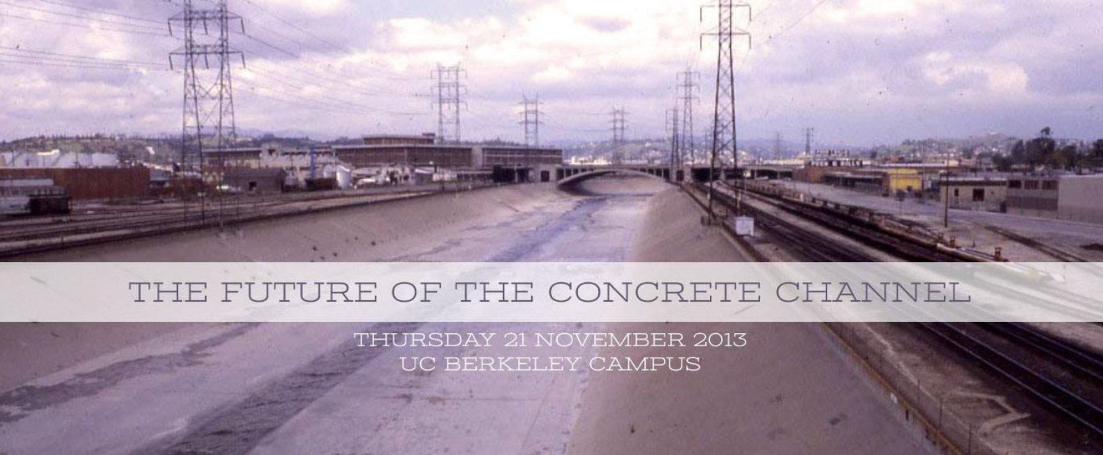
MacAdams was a featured speaker at (and a key inspiration for) the conference The Future of the Concrete Channel convened by the Department of Landscape Architecture and Environmental Planning in November 2013, organized by Matt Kondolf and Raymond Wong. The conference program featured these topics and speakers:
Policy background Scott Nicholson USACE HQ, Rethinking flood control 23 years later Phil Williams PWA-ESA, Overview of concrete channels around the SF Bay Raymond Wong, UCB, A historical perspective Bill Kier, Kier Associates, Contra Costa County Mike Carlson CCCFC, Santa Clara County Jim Fiedler, SCVWD, Menomonee River David Fowler, Milwaukee MSD, Resonance in contemporary culture Chip Sullivan, UCB, David Fletcher, California College of the Arts, A 50-year plan for Contra Costa Streams Mitch Avalon, CCCFC, The Ala Wai Canal project feasibility study Scott Nicholson, Replacing aging concrete channels David Fowler, MMSD, Los Angeles River Ecosystem Restoration Project Carol Armstrong, City of Los Angeles, Evolving concepts of restoration Lewis MacAdams, FOLAR, Overcoming barriers to reinventing concrete channels Jeff Haltiner, UCB & ESA-PWA, Kathy Schaefer, FEMA, Louise Mozingo, UC Berkeley, Mitch Avalon, CCCFC; Ralph Johnson, Alameda County.
Deliberate high-flow releases are increasingly made from dams to mimic effects of floods and interact with the channel to produce biophysical changes in channel characteristics, such as removing fine sediment from downstream aquatic habitats. These are a special case of environmental flows intended to mitigate geomorphic/ecological effects of dams, commonly termed flushing flows. In a new publication, Remi Loire and colleagues propose new terms for these high flow releases: morphogenic releases, or ecomorphogenic releases for flows intended specifically to improve aquatic and riparian habitats. The paper, published in Earth Science Reviews, reviews objectives of these flows, experiences gained from their implementation, and potential conflicts with environmental, socio-economic, and dam-operational issues. The paper is available until 21 February 2021 for free download here.
Loire, R, H Piégay, J-R Malavoi, GM Kondolf, and LA Bêche. From flushing flows to eco-geomorphic flow releases: evolving terminology, practice, and integration into regulated river management. Earth Science Reviews 213: 103475
Many cities worldwide now have available waterfront land, often in the city center, thanks to de-industrialization and concentration of navigation elsewhere. As cities seek to take advantage of this remarkable real estate, they may be prone to some classic ‘traps’ such as copying projects successful in another city but which fail in the new location due to differences in scale, topography, urban form, etc. In this recent publication, Pedro Pinto and Matt Kondolf present an idiosyncratic list of ‘wrongs’ that are evident in many such projects. The paper is freely available, via open access here.
Pinto, JP, and GM Kondolf. 2020. The fit of urban waterfront interventions: matters of size, money and function. Sustainability 12: 4079; doi:10.3390/su12104079

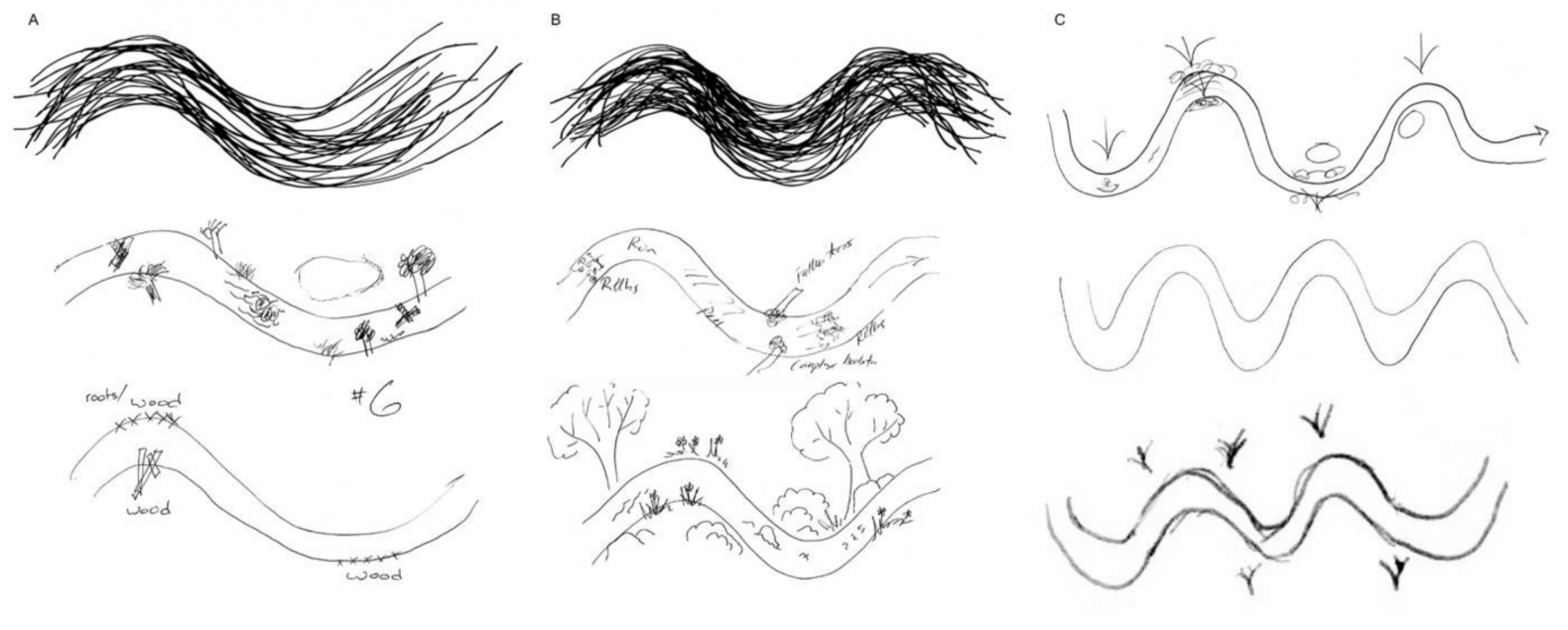
River restoration projects in North America that involve reconfiguration of stream channels are dominated by symmetrical, single-thread meandering channels. Although the meander dimensions are commonly justified by relations between channel width and meander wavelength, the universal preference for single-thread meandering channels in restoration projects is rarely questioned. The aesthetic appeal of s-shaped curves in art and landscape design may help explain the prevalence of this form in river restoration projects. Riverlab alumna Kristen Wilson (Nature Conservancy) gave 300 freshwater scientists attending her keynote talk 5 minutes to draw a restored stream. She compiled the results to see what mental images these scientists had for restored channels. Most depicted single-thread meanders for their restored channel, although there were interesting variants. See Kristen’s just-published paper here.
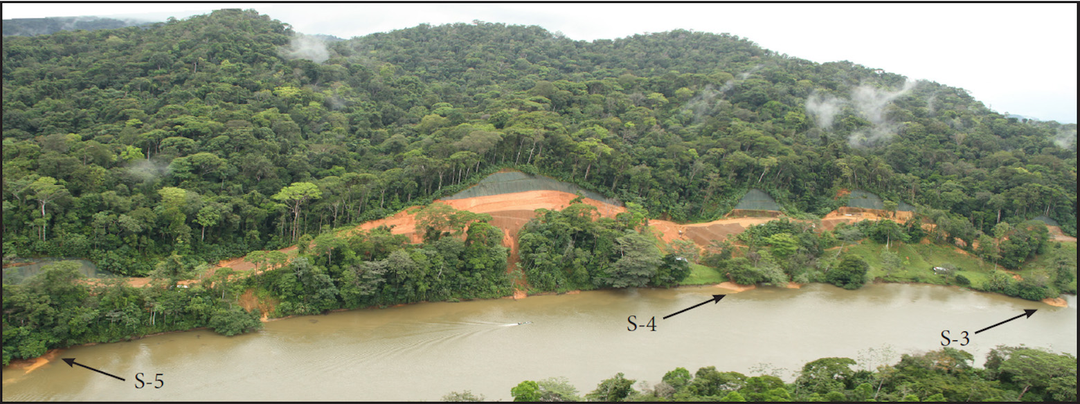
Throughout the humid tropics, increased land disturbance and concomitant road construction increases erosion and sediment delivery to rivers. Building road networks in developing countries is commonly a priority for international development funding based on anticipated socio-economic benefits. Yet the resulting erosion from roads, which recent studies have shown result in at least ten-fold increases in erosion rates, is not fully accounted for. While effects of road-derived sediment on aquatic ecosystems have been documented in temperate climates, little has been published on the effects of road-induced sediment on aquatic ecosystems in developing countries of the tropics. Along the south bank of the Rio San Juan (Nicaragua and Costa Rica), attempts to build a road without engineering or plans resulted in massive failures and erosion in areas where steep slopes impinge upon the river bank. Pre-existing tributary streams received elevated sediment loads, creating new deposits on pre-existing tributary deltas. In some reaches with rapidly eroding sites, completely new deltas of freshly deposited sediment were formed, prograding into the river channel.
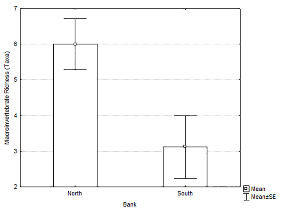
Riverlab alumni Blanca Rios and Scott Walls joined with Matt Kondolf to study periphyton biomass and macroinvertebrate communities on the deltas of Río San Juan tributaries, comparing north-bank tributaries draining undisturbed rain forest with south-bank tributaries receiving runoff from the partially-built road experiencing rapid erosion. Periphyton biomass, richness and abundance of macroinvertebrates overall, and richness and abundance of Ephemeroptera, Plecoptera and Trichoptera were higher on the north-bank tributary deltas than the south-bank tributary deltas. These findings were consistent with prior studies in temperate climates showing detrimental effects of road-derived fine sediment on aquatic organisms. A Non-Metric Multidimensional Scaling (NMDS) analysis showed the impacted community on the south-bank deltas was influenced by poorly-sorted substrate with greater proportions of fine sediment and higher water temperatures. The paper is freely available (open-access) here.
Rios-Touma, B, GM Kondolf, and SP Walls. 2020. Impacts of sediment derived from erosion of partially-constructed road on aquatic organisms in a tropical river: the Río San Juan, Nicaragua and Costa Rica. PLoSONE 15(11):e0242356. https://doi.org/10.1371/journal.pone.0242356
With great regret, we cancel the 2020 shortcourse at Sagehen Creek Field Station, due to the many complications arising from the CVID-19 pandemic and the challenges in avoiding problems in holding the shortcourse at the station. Those already registered are entitled to a full refund or may defer their participation to next year’s course offering, 16-20 August 2021. We apologize for this very disappointing news, but look forward to better conditions under which we can once again hold the course next year. We thank you for your understanding.
Matt Kondolf and the Sagehen Teaching Team
Geomorphic and Ecological Fundamentals for River and Stream Restoration